
Portal:Myanmar
ကြိုဆိုပါတယ်။ / Welcome to the Myanmar Portal 

Myanmar, officially the Republic of the Union of Myanmar and also known as Burma (the official name until 1989), is a country in Southeast Asia. It is the largest country by area in Mainland Southeast Asia and has a population of about 55 million. It is bordered by Bangladesh and India to its northwest, China to its northeast, Laos and Thailand to its east and southeast, and the Andaman Sea and the Bay of Bengal to its south and southwest. The country's capital city is Naypyidaw, and its largest city is Yangon (formerly Rangoon).
Myanmar is a member of the East Asia Summit, Non-Aligned Movement, ASEAN, and BIMSTEC, but it is not a member of the Commonwealth of Nations despite once being part of the British Empire. Myanmar is a Dialogue Partner of the Shanghai Cooperation Organization. The country is very rich in natural resources, such as jade, gems, oil, natural gas, teak and other minerals, as well as also endowed with renewable energy, having the highest solar power potential compared to other countries of the Great Mekong Subregion. However, Myanmar has long suffered from instability, factional violence, corruption, poor infrastructure, as well as a long history of colonial exploitation with little regard to human development. In 2013, its GDP (nominal) stood at US$56.7 billion and its GDP (PPP) at US$221.5 billion. The income gap in Myanmar is among the widest in the world, as a large proportion of the economy is controlled by cronies of the military junta. Myanmar is one of the least developed countries; as of 2020, according to the Human Development Index, it ranks 147 out of 189 countries in terms of human development, the lowest in Southeast Asia. Since 2021, more than 600,000 people were displaced across Myanmar due to the surge in violence post-coup, with more than 3 million people in dire need of humanitarian assistance. (Full article...)
Selected articles -
-

Lake of No Return (Naung Yang in Tai languages) is a body of water in Myanmar, lying in the area of the Pangsau Pass (3727') on the India–Myanmar border south of Pangsau (also called Pansaung) village. The lake is 1.4 km in length and 0.8 km in width at its widest part. It is located 2.5 km to the southwest of the Ledo Road, formerly called Stilwell Road, the road the Western Allies started building in 1942 to supply the Chinese armies of Chiang Kai-shek.
The area is home to the Tangsa community. Since the improvement of relations between India and Myanmar , the lake has come to play a part in the development of tourism in the nearby Indian Changlang District, which borders on Myanmar. (Full article...) -
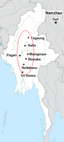
The Early Pagan Kingdom (Burmese: ခေတ်ဦး ပုဂံ ပြည်) was a city-state that existed in the first millennium CE before the emergence of the Pagan Empire in the mid 11th century. The Burmese chronicles state that the "kingdom" was founded in the second century CE. The seat of power of the small kingdom was first located at Arimaddana, Thiri Pyissaya, and Tampawaddy until 849 CE when it was moved to Pagan (Bagan).
Radiocarbon dating shows the earliest human settlement in the Pagan region dates only from the mid-7th century CE. It existed alongside Pyu city-states that dominated Upper Burma. The city-state of Pagan, according to mainstream scholarship, was founded in the mid 9th century by the Mranma of Nanzhao Kingdom. Burmans at Pagan expanded irrigation-based cultivation while borrowing extensively from the Pyus' predominantly Buddhist culture. It was one of many competing city-states in the Pyu realm until the late 10th century when the principality began absorbing its surrounding states. The expansion accelerated in the 1050s and 1060s when King Anawrahta founded the Pagan Empire, the first ever unification of the Irrawaddy valley and its periphery. (Full article...) -
Insurgencies have been ongoing in Myanmar since 1948, the year the country, then known as Burma, gained independence from the United Kingdom. The conflict has largely been ethnic-based, with several ethnic armed groups fighting Myanmar's armed forces, the Tatmadaw, for self-determination. Despite numerous ceasefires and the creation of autonomous self-administered zones in 2008, many armed groups continue to call for independence, increased autonomy, or the federalisation of the country. The conflict is the world's longest ongoing civil war, having spanned more than seven decades. (Full article...) -
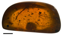
Wing of the dragonfly Burmalindenia in a cabochon of Burmese amber, showing typical red colouration of the amber. Scale bar = 5mm
Burmese amber, also known as Burmite or Kachin amber, is amber from the Hukawng Valley in northern Myanmar. The amber is dated to around 100 million years ago, during the latest Albian to earliest Cenomanian ages of the mid-Cretaceous period. The amber is of significant palaeontological interest due to the diversity of flora and fauna contained as inclusions, particularly arthropods including insects and arachnids but also birds, lizards, snakes, frogs and fragmentary dinosaur remains. The amber has been known and commercially exploited since the first century AD, and has been known to science since the mid-nineteenth century. Research on the deposit has attracted controversy due to its alleged role in funding internal conflict in Myanmar and hazardous working conditions in the mines where it is collected. (Full article...) -
The Irrawaddy River (Burmese: ဧရာဝတီမြစ်, pronounced [ʔèjàwədì mjɪʔ], official romanisation: Ayeyarwady) is the largest river in Myanmar. Originating from the confluence of the N'mai and Mali rivers, it flows from north to south before emptying through the Irrawaddy Delta in the Ayeyarwady Region into the Andaman Sea. Its drainage basin of about 404,000 square kilometres (156,000 sq mi) covers 61% of the land area of Burma, and contains five of its largest cities.
As early as the sixth century, the river was used for trade and transport, and an extensive network of irrigation canals was developed to support agriculture. The river is still of great importance as the largest commercial waterway of Myanmar. It also provides important ecosystem services to different communities and economic sectors, including agriculture, fisheries, and tourism. (Full article...) -
Hkakaborazi National Park is a national park in northern Myanmar with an area of 1,472 sq mi (3,810 km2). It was established in 1998.
It surrounds Hkakabo Razi, the highest mountain in the country.
It ranges in elevation from 2,950 to 18,730 ft (900 to 5,710 m) comprising evergreen forest and mixed deciduous forests in Nogmung Township, Kachin State. It is managed by the Nature and Wildlife Conservation Division.
It is contiguous with Bumhpa Bum Wildlife Sanctuary and Hukaung Valley Wildlife Sanctuary. These protected areas together with Hponkanrazi Wildlife Sanctuary comprise the largest continuous expanse of natural forest called the Northern Forest Complex stretching over an area of 11,624 sq mi (30,110 km2). Its objective is to conserve the biodiversity of the Ayeyarwady and Chindwin river basins. (Full article...) -
The first Mongol invasions of Burma (Burmese: မွန်ဂို–မြန်မာ စစ် (၁၂၇၇–၁၂၈၇); Chinese: 元緬戰爭) were a series of military conflicts between Kublai Khan's Yuan dynasty, a division of the Mongol Empire, and the Pagan Empire that took place between 1277 and 1287. The invasions toppled the 250-year-old Pagan Empire, and the Mongol army seized Pagan territories in present-day Dehong, Yunnan and northern Burma to Tagaung. The invasions ushered in 250 years of political fragmentation in Burma and the rise of ethnic Tai-Shan states throughout mainland Southeast Asia.
The Mongols first demanded tribute from Pagan in 1271–72, as part of their drive to encircle the Song dynasty of China. When King Narathihapate refused, Emperor Kublai Khan himself sent another mission in 1273, again demanding tribute. It too was rejected. In 1275, the emperor ordered the Yunnan government to secure the borderlands in order to block an escape path for the Song, and permitted a limited border war if Pagan contested. Pagan did contest but its army was driven back at the frontier by the Mongol Army in 1277–78. After a brief lull, Kublai Khan in 1281 turned his attention to Southeast Asia, demanding tribute from Pagan, the Khmer Empire, Đại Việt and Champa. When the Burmese king again refused, the emperor ordered an invasion of northern Burma. Two dry season campaigns (1283–1285) later, the Mongols had occupied down to Tagaung and Hanlin, forcing the Burmese king to flee to Lower Burma. The Mongols organized northern Burma as the province of Zhengmian. (Full article...) -
Aung San (Burmese: ဗိုလ်ချုပ် အောင်ဆန်း; MLCTS: aung hcan:, pronounced [àʊɰ̃ sʰáɰ̃]; 13 February 1915 – 19 July 1947) was a Burmese politician, independence activist and revolutionary. He was instrumental in Myanmar's struggle for independence from British rule, but he was assassinated just six months before his goal was realized. Aung San is considered the founder of modern-day Myanmar and the Tatmadaw (the country's armed forces), and is commonly referred to by the titles "Father of the Nation", "Father of Independence", and "Father of the Tatmadaw".
Devoted to ending British Colonial rule in Burma, Aung San founded or was closely associated with many Burmese political groups and movements and explored various schools of political thought throughout his life. He was a life-long anti-imperialist and studied socialism as a student. In his first year of university he was elected to the executive committee of the Rangoon University Students' Union and served as the editor of its newspaper. He joined the Thakin Society in 1938 and served as its general secretary. He also helped establish the Communist Party of Burma in 1939 but quit shortly afterwards due to vehement disagreements with the rest of the party leadership. He subsequently co-founded the People's Revolutionary Party (later the Burma Socialist Party) with the primary goal of Burmese independence from the British. (Full article...) -
The sun bear (Helarctos malayanus) is a species in the family Ursidae (the only species in the genus Helarctos) occurring in the tropical forests of Southeast Asia. It is the smallest bear species, standing nearly 70 cm (28 in) at the shoulder and weighing 25–65 kg (55–143 lb). It is stockily built, with large paws, strongly curved claws, small, rounded ears and a short snout. The fur is generally short and jet black, but can vary from grey to red. The sun bear gets its name from its characteristic orange to cream-coloured chest patch. Its unique morphology—inward-turned front feet, flattened chest, powerful forelimbs with large claws—suggests adaptations for climbing.
The most arboreal (tree-living) of all bears, the sun bear is an excellent climber and sunbathes or sleeps in trees 2 to 7 m (7 to 23 ft) above the ground. It is mainly active during the day, though nocturnality might be more common in areas frequented by humans. Sun bears tend to remain solitary, but sometimes occur in twos (such as a mother and her cub). They do not seem to hibernate, possibly because food resources are available the whole year throughout the range. Being omnivores, sun bears' diet includes ants, bees, beetles, honey, termites, and plant material such as seeds and several kinds of fruits; vertebrates such as birds and deer are also eaten occasionally. They breed throughout the year; individuals become sexually mature at two to four years of age. Litters comprise one or two cubs that remain with their mother for around three years. (Full article...) -

---- Countries that have officially condemned the events in MyanmarCountries that have offered humanitarian aid to Rohingya MuslimsCountries that have given support for Myanmar's policies regarding Rohingya Muslims
The Rohingya genocide is a term applied to the persecution—including mass killings, mass rapes, village-burnings, deprivations, ethnic cleansing, and internments—of the Rohingya people of western Myanmar (particularly northern Rakhine state).
International reaction focused on pressuring Aung San Suu Kyi to condemn the atrocities and address human-rights issues. Suu Kyi's power was restricted under the 2008 Constitution of Myanmar, which placed key ministries like home, border affairs and defense under military control and reserved 25% of seats in the legislature for serving military officers. Military chief Min Aung Hlaing is regarded as the most powerful person in the country, and in 2021 he launched a military coup, seizing control of the government. (Full article...)


.png)


Did you know (auto-generated) -

- ... that Maung O, Prince of Salin, and his sister Nanmadaw Me Nu became de facto rulers of Burma when King Bagyidaw was suffering from depression?
- ... that Aung Myo Min, Union Minister of Human Rights for the National Unity Government of Myanmar, is the country's first openly LGBT minister?
- ... that one academic described the introduction of femboys to Myanmar as a tactic to achieve an "ideological revolution"?
- ... that while defending Zaw Myint Maung following his arrest by the Myanmar junta, lawyer Ywet Nu Aung was herself arrested and charged?
- ... that as part of the coronation of Mindon Min, the square yuzana around the capital was designated a sanctuary?
- ... that Maw Htun Aung, a Shan Nationalities League for Democracy candidate in the 2020 Myanmar general election, is Kachin, not Shan?
- ... that the Burmese Buddhist monk Sagyo Thu-Myat successfully lobbied for the recalibration of the Burmese calendar?
- ... that Molly Burman resumed releasing music three years later after finding that "Happy Things" had accrued a million streams on Spotify?
Related portals and projects
General images -
-
 Aerial view of a burned Rohingya village in Rakhine state, Myanmar, September 2017 (from History of Myanmar)
 -
 19th-century funeral cart and spire, which would form part of the procession from the home to the place of cremation (from Culture of Myanmar)
 -
 A group of Buddhist worshipers at Shwedagon Pagoda, an important religious site for Burmese Buddhists (from Culture of Myanmar)
 -
 Pagan Kingdom during Narapatisithu's reign. Burmese chronicles also claim Kengtung and Chiang Mai. Core areas shown in darker yellow. Peripheral areas in light yellow. Pagan incorporated key ports of Lower Burma into its core administration by the 13th century. (from History of Myanmar)
 -
 Grandfather Island, Dawei (from Geography of Myanmar)
 -

-
 Myinhkin thabin - equestrian sport (from Culture of Myanmar)
 -
 Protesters in Yangon carrying signs reading "Free Daw Aung San Suu Kyi" on 8 February 2021. (from History of Myanmar)
 -

-
 The paddle steamer Ramapoora (right) of the British India Steam Navigation Company on the Rangoon river having just arrived from Moulmein. 1895. Photographers: Watts and Skeen (from History of Myanmar)
 -
 The restored Taungoo or Nyaungyan dynasty c. 1650 CE. (from History of Myanmar)
 -

-
 A wedding procession, with the groom and bride dressed in traditional Burmese wedding clothes, reminiscent of royal attire (from Culture of Myanmar)
 -
 A large fracture on the Mingun Pahtodawgyi caused by the 1839 Ava earthquake. (from Geography of Myanmar)
 -
 Two female musicians play the saung at a performance in Mandalay. (from Culture of Myanmar)
 -
 British soldiers on patrol in the ruins of the Burmese town of Bahe during the advance on Mandalay, January 1945. (from History of Myanmar)
 -
 Former US President Barack Obama poses barefoot on the grounds of Shwedagon Pagoda, one of Myanmar's major Buddhist pilgrimage sites. (from Culture of Myanmar)
 -

-
 Jade Mine in Hpakant (from Geography of Myanmar)
 -
 Boxing match, 19th-century watercolour (from Culture of Myanmar)
 -
 Recorder's Court on Sule Pagoda Road, with the Sule Pagoda at the far end, Rangoon, 1868. Photographer: J. Jackson. (from History of Myanmar)
 -
 Political Map of Burma (Myanmar) c. 1450 CE. (from History of Myanmar)
 -
 British soldiers remove their shoes at the entrance of Shwedagon Pagoda. To the left, a sign reads "Foot wearing is strictly prohibited" in Burmese, English, Tamil, and Urdu. (from Culture of Myanmar)
 -
 Sculpture of Myanmar mythical lion (from Culture of Myanmar)
 -
 A wide range of Burmese lacquerware from Bagan (from Culture of Myanmar)
 -
 Hlei pyaingbwè - a Burmese regatta (from Culture of Myanmar)
 -
 Mountains near Pindaya on the Shan Plateau (from Geography of Myanmar)
 -
 Protesters in Yangon with a banner that reads non-violence: national movement in Burmese, in the background is Shwedagon Pagoda. (from History of Myanmar)
 -
 The shores of Irrawaddy River at Nyaung-U, Bagan (from Geography of Myanmar)
 -
 Vegetable stall on the roadside at the Madras Lancer Lines, Mandalay, January 1886. Photographer: Hooper, Willoughby Wallace (1837–1912). (from History of Myanmar)
 -
 A theatrical performance of the Mon dance (from Culture of Myanmar)
 -
 Myanmar (Burma) map of Köppen climate classification (from Geography of Myanmar)
 -
 Aung San Suu Kyi addresses crowds at the NLD headquarters shortly after her release. (from History of Myanmar)
 -
 Salween river at Mae Sam Laep on the Thai-Myanmar border (from Geography of Myanmar)
 -
 Temples at Mrauk U, was the capital of the Mrauk U Kingdom, which ruled over what is now Rakhine State. (from History of Myanmar)
 -
 A bull fight, 19th-century watercolour (from Culture of Myanmar)
 -
 Saint Mary's Cathedral in Downtown Yangon is the largest Roman Catholic cathedral in Burma. (from Culture of Myanmar)
 -
 Mount Popa, a dormant volcano in the Central Lowlands (from Geography of Myanmar)
 -
 British soldiers dismantling cannons belonging to King Thibaw's forces, Third Anglo-Burmese War, Ava, 27 November 1885. Photographer: Hooper, Willoughby Wallace (1837–1912). (from History of Myanmar)
 -
 Portuguese ruler and soldiers mounting an Elephant. Philips, Jan Caspar (draughtsman and engraver) (from History of Myanmar)


_headquarter.jpg)


Major topics
Categories

More topics

Associated Wikimedia
The following Wikimedia Foundation sister projects provide more on this subject:
-
 Commons
Free media repository -
 Wikibooks
Free textbooks and manuals -
 Wikidata
Free knowledge base -
 Wikinews
Free-content news -
 Wikiquote
Collection of quotations -
 Wikisource
Free-content library -
 Wikiversity
Free learning tools -
 Wikivoyage
Free travel guide -
 Wiktionary
Dictionary and thesaurus


